History of Carolina before it divided
into North & South Carolina in 1729

The actual North/South Carolina border was disputed for years until 1771.
The actual North/South Carolina border was disputed for years until 1771.
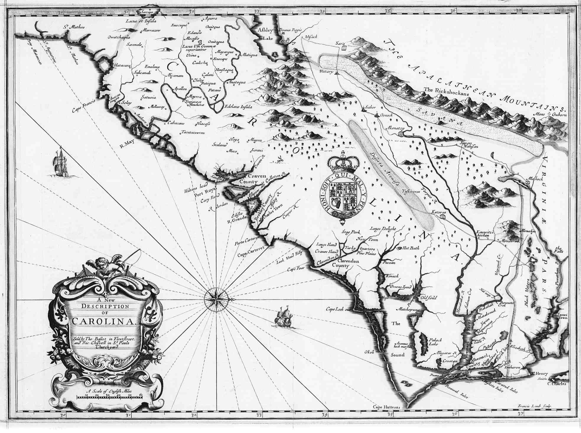
Following the restoration of the monarchy in 1660, Charles II of England rewarded eight persons on March 24, 1663, for their faithful support in his efforts to regain the throne of England. He granted the eight grantees called Lords Proprietors or simply Proprietors the land called Carolina, in honor of Charles I, his father. The 1663 charter granted the Lords Proprietor title to all of the land from the southern border of the Virginia Colony from 36 degrees north to 31 degrees north (along the coast of present-day Georgia). In 1665, the charter was revised slightly, with the northward boundary extended to 36 degrees 30 minutes north to include the lands of settlers along the Albemarle Sound who had left the Virginia Colony. Likewise the southern boundary was moved south to 29 degrees north, just south of present-day Daytona Beach, Florida, which had the effect of including the existing Spanish settlement at St. Augustine. The charter also granted all the land between from these bounds from the Atlantic to the South Seas.
The Lords Proprietors named in the charter were: Henry Hyde, 2nd Earl of Clarendon, George Monck, 1st Duke of Albemarle, William Craven, 1st Earl Craven, John Berkele, 1st Baron Berkeley of Stratton, Anthony Ashley Cooper, 1st Earl of Shaftesbury, Sir George Carteret, Sir William Berkeley (brother of John), and Sir John Colleton. Of the eight, the one taking the most active interest in Carolina was Lord Shaftesbury, whose secretary, the philosopher John Locke, purportedly wrote a never-ratified constitution of Carolina. Some of the other Lords Proprietors also had interests in other colonies: William Berkeley in Virginia, John Berkeley and George Carteret in the Province of New Jersey.
The Lords Proprietors, while their authority was granted by royal charter, were nonetheless able to exercise that authority with nearly the power of an independent sovereign. The actual government consisted of a Governor, a powerful Council, half of which was appointed by the Lords Proprietors, and a relatively weak popularly elected Assembly.
Although the Lost Colony on Roanoke Island represents the first English attempt at settlement in the Carolina territory, the first permanent English settlement in the area was in 1653, established mainly by emigrants from the Virginia Colony with others from New England and Bermuda. Pre-empting the royal charter by ten years, they settled on the banks of the Chowan and Roanoke Rivers in the Albemarle Sound area in the northeast corner of present-day North Carolina. The Albemarle Settlements came to be known in Virginia as "Rogues' Harbor."
In 1665, Sir John Yeamans established a second permanent settlement on the Cape Fear River, near present-day Wilmington, North Carolina, called Clarendon.
Another region was settled under the Lords Proprietors in 1670 to the south of the other settlements, around present-day Charleston, South Carolina. The Charleston settlement developed more rapidly than the Albemarle and Cape Fear settlements due to the advantages of a natural harbor and easy access to trade with the West Indies. Lord Shaftesbury specified the street plan for Charleston and the nearby Ashley and Cooper Rivers are named for him.
That southern settlement, originally named Charles Towne after King Charles and later became known as Charleston, was the principal seat of government for the entire province. However, due to their remoteness from each other, the northern and southern sections of the colony operated more or less independently until 1691 with the appointment of Philip Ludwell as governor of both areas. From that time until 1708, the northern and southern settlements were under common government. The north continued to have its own assembly and council, the Governor resided in Charleston and appointed a deputy governor for the north. The Province of Carolina from 1663 to 1729, was a North American British colony. Dissent over governance of the province led to a division between North and South in 1710 and it grew until 1729 when the Province of Carolina was officially divided into the Provinces of North and South Carolina.
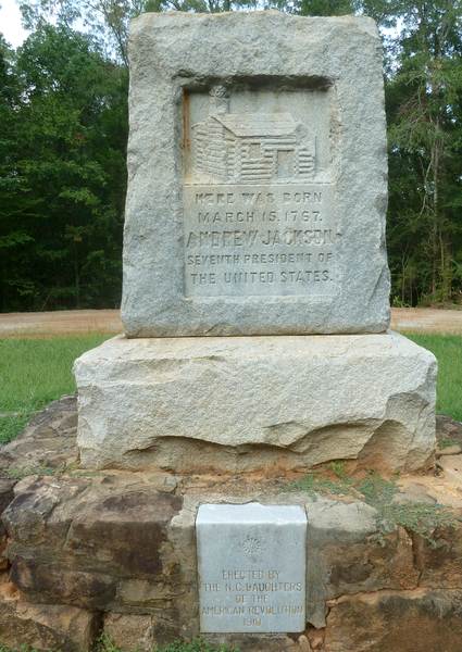
In the present day, there's still an ongoing dispute between North Carolina and South Carolina over which State is the actual birthplace of the Seventh President of the United States Andrew Jackson. In 1910, a North Carolina Daughters of the American Revolution chapter erected an engraved NC Andrew Jackson Birthplace stone monument in Waxhaw, NC to mark the exact spot of the cabin where they believe he was born. This monument says "Here was born March 15, 1767 ANDREW JACKSON Seventh President of The United States and depicts the log cabin in which he was born. The nearby Museum of the Waxhaws has a large Andrew Jackson head bust statue on display beside a wooden plaque calling him a NC Native son.
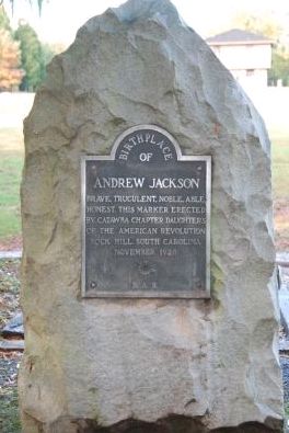
Not to be outdone by their Northern neighbors, a South Carolina Daughters of the American Revolution chapter erected an engraved SC Andrew Jackson Birthplace stone monument of their own in 1929 and another using Jackson's own words to proclaim him a SC Native son. The South Carolina General Assembly authorized State funds for Andrew Jackson State Park (built on Andrew Jackson Park Road) in Lancaster, SC. It has 360 acres, a mini-museum, camping and a huge bronze statue depicting Jackson on a horse as a boy. Historical road signs in both states also make competing claims. Which state is right? Nobody knows for sure. If you want to go visit both States' Andrew Jackson birthplace monuments in person, read THIS!


![]() |
|
![]() |
|
![]() |
|
|
|
![]()
![]() Home | How it works | FAQ | Terms of Service | Top 10 Banner Ads | Top Carolina Sites
Home | How it works | FAQ | Terms of Service | Top 10 Banner Ads | Top Carolina Sites
Order | Banner Ad Comeback | Carolina Map (No NC/SC Border) | Make a Banner Ad Free
All content is Copyright © 2017 by Carolina Banner Exchange Network. All rights reserved.
No content may be reproduced, altered or redistributed without our express written consent.